
For drone pilots
Your whole shoot. One workflow.
Upload a flight. Epiloft finds every lot in your shots, draws and numbers the lines, pins nearby places, links your 360s into a tour and builds a branded share page. One tool from card reader to client link.
Then it does what no editor can
This is the part your competition cannot hand a client, because their software has no idea where the lots are.
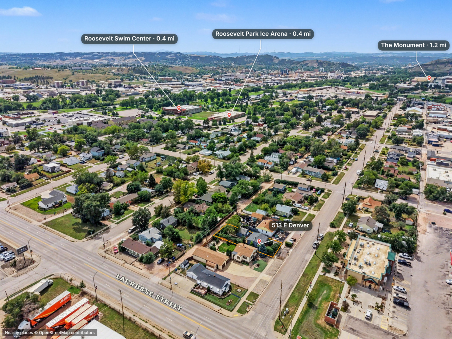
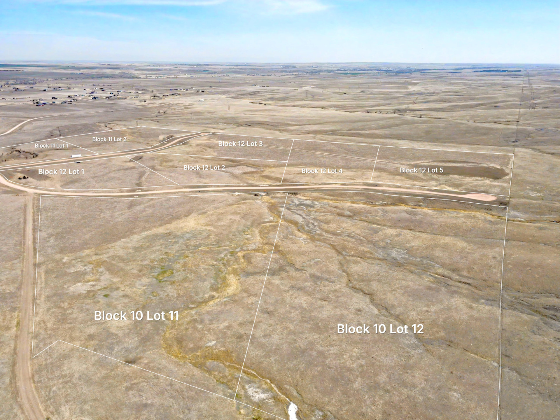
Auto lot lines that follow the ground
Open a photo and Epiloft detects every lot in the shot, projects them all using the camera pose and terrain, numbers them and adds the disclaimer. The line climbs the hill instead of floating over it.
The same lines go into 360 panoramas, which link into a tour automatically by GPS, and onto drone video, where they stay on the ground through an orbit and hide behind buildings.
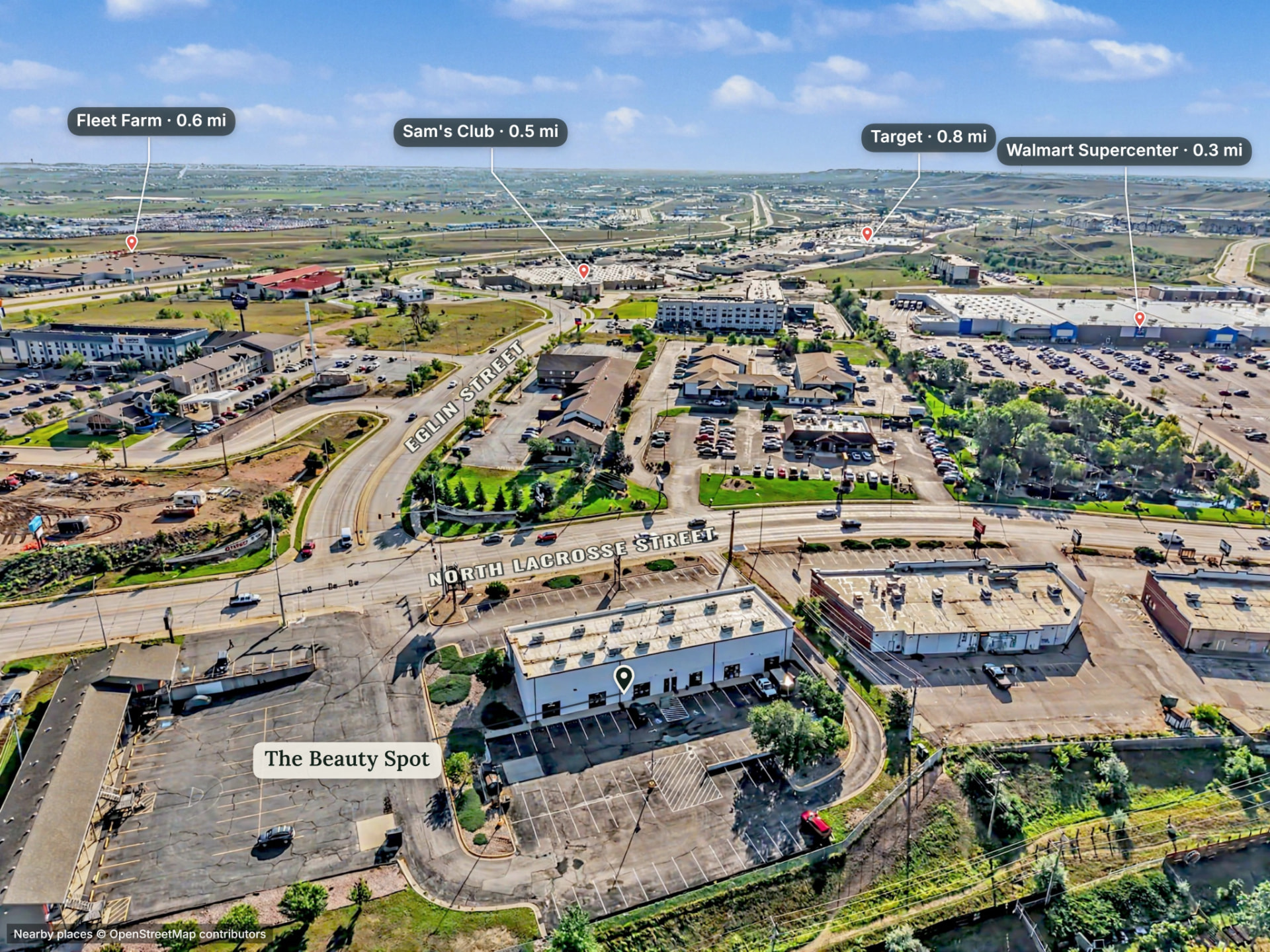
Nearby places, found and placed
Epiloft reads the camera pose, finds real landmarks around the shot and drops labelled pins where they actually sit in the frame. Pick which ones matter, restyle them, drag a label, done. Place data from OpenStreetMap contributors.
Full markup toolkit on every photo: arrows, shapes, freehand, highlighter, callouts, spotlights, layers and locking, all of it exported and shared exactly as you drew it.
Shooting big land?
Do you shoot new subdivisions? Ranches? Large commercial properties? Our interactive map will make your clients love you.
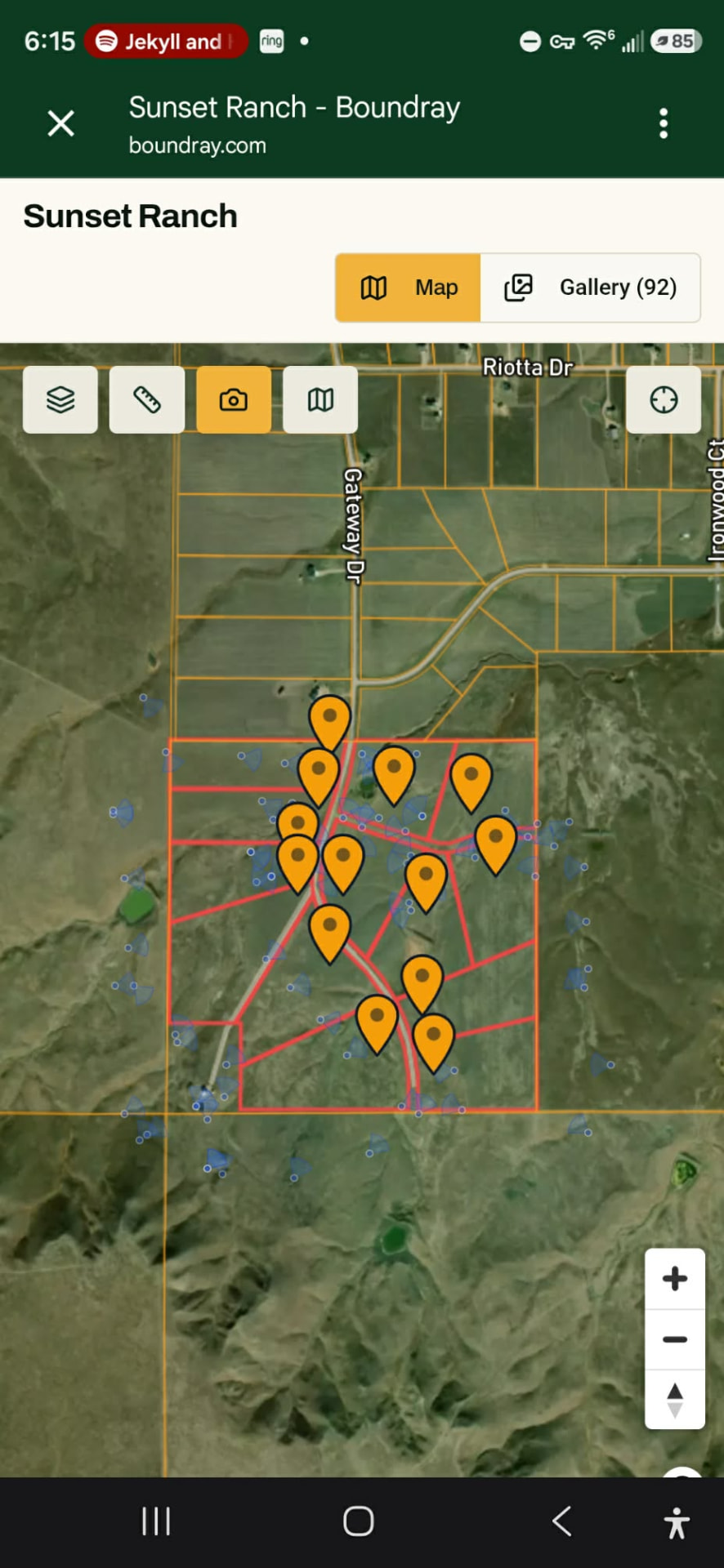
On a big parcel, a folder of files is useless. Nobody can tell which pond, which pad, which lot. Epiloft pins every photo on a map of the property, so your client taps a corner of the land and sees exactly what you shot there.
Every photo is tied to the lots it shows, so this is the upgrade your buyer actually feels: a developer walking lot by lot, a ranch broker sending one link to an out-of-state buyer, a commercial client checking the loading dock without calling you.
Before and after the shoot
Explore map for scouting
A roaming map with the parcel layer and owner names. Find the lot and check its shape before you drive out.
Site flight conditions
Check the property itself before you drive out: wind and gusts up to 400 ft, cloud base, density altitude and GPS space weather, hour by hour. No separate forecast app.
Know who opened it
Share page analytics show views and engagement, and you can send every visit to your own GA4 property.
The deliverable
The share page is the product. One link, opens on a phone, nothing to download and nothing to install.
What your client sees
Finished photos with lot lines and labels in place, full-resolution downloads, the property map with every shot pinned, and a 3D view when you flew for one. They swipe. That is the whole learning curve.
Your branding, not ours
Your logo, your name, your contact. Epiloft does not put its badge on your work on a paid plan, and your client never has to know what you built it in.
Send it any way you like
Text the link, embed it on a listing site, or hand your client a free viewer account. Downloadable files are still there when someone wants the originals.
Pricing
14 days free, no card. Up to 5 projects, 1,500 photos in total and 25 GB of storage. Share pages are preview-only and no 3D processing or AI Enhance credits are included. Add a card any time to unlock 100 3D processing credits and 20 AI Enhance credits. The trial then converts to the plan you pick on day 15 unless you cancel.
Do you need to process 3D models and orthomosaic tiles?Just delivering photos and maps? Photo Pro. Processing 3D models and orthos? 3D Studio.See what 3D Studio does →
Free trial
$0for 14 days
Start with no card. Bring a real shoot, or play with the sample property first.
- Up to 5 projects, 1,500 photos in total and 25 GB of storage
- Automatic lot lines on photos and 360s, plus place pins and tours
- Share pages are preview-only; they go live when you subscribe
- No 3D processing or AI Enhance credits until you add a card
- Add a card for 100 3D processing and 20 AI Enhance credits
- Exports carry an Epiloft watermark during the trial
With a card, converts to the plan and billing period you pick (Photo Pro $49 monthly or $492 a year, 3D Studio $179 monthly or $1,788 a year) on day 15 unless you cancel.
Epiloft Photo Pro
Founding pricing$41/month, billed annually
or $49 month-to-month
Lock in this rate for as long as your subscription stays active. Prices will rise as the platform grows; founding members keep theirs.
The photo and map product, unlimited. Every page live while you subscribe. Your brand, not ours.
- Unlimited projects
- Photo editor with terrain-aware approximate parcel boundaries
- 360 panoramas with approximate parcel boundaries
- Printable property report (PDF)
- Nearby-place pins, markup and map projects
- Publish photo and map share pages
- White-label pages and exports
- Explore map included
- Flight mission planner
- Site flight conditions (winds aloft, cloud base, GPS weather)
- 250 GB storage
Annual works out to $492 a year. No 3D processing or model import. Need a 3D model? Run a single one for $30 plus processing credits.
Epiloft 3D Studio
Founding pricing$149/month, billed annually
or $179 month-to-month
Lock in this rate for as long as your subscription stays active. Prices will rise as the platform grows; founding members keep theirs.
Everything in Photo Pro, plus the whole Studio: 3D models and orthomosaic tiles.
- Everything in Epiloft Photo Pro
- Cloud photogrammetry and the 3D model studio
- Publish 3D viewers and ortho tiles to share pages
- Bring your own model, Foundation Fit, sun and flood on 3D
- 500 GB storage
Annual works out to $1,788 a year. Cloud processing is still billed with prepaid credits.
14 days free, no card. Up to 5 projects, 1,500 photos in total and 25 GB of storage. Share pages are preview-only and no 3D processing or AI Enhance credits are included. Add a card any time to unlock 100 3D processing credits and 20 AI Enhance credits. The trial then converts to the plan you pick on day 15 unless you cancel. Photo Pro is $49 monthly or $492 a year; 3D Studio is $179 monthly or $1,788 a year. Cloud 3D processing beyond the included credits is billed with prepaid credits.
Built by a working real estate broker, general contractor, and licensed drone pilot - because the existing tools weren't built for how this job actually works.
Lot lines are approximate, from public parcel data, not a survey.
Flying with a crew? See team plans.
Straight answers
- Isn't putting lot lines on photos a liability?
- The lines come from the same public county parcel data shown in GIS viewers and the land and listing apps your clients already use. Epiloft projects that data onto your photo and labels it approximate on every image and export—never a survey. For the legal boundary, hire a licensed land surveyor.
- Do I have to use your enhancement?
- No. Bring photos you already edited and they go straight into the project untouched. We never re-process your files unasked, and nothing is enhanced unless you pick the photos and confirm the cost.
- What drones and cameras work?
- Anything that writes normal image files. DJI, Autel and Skydio drones, mirrorless and DSLR bodies, phone shots in a pinch. DJI 360 panoramas work too, with the approximate parcel boundary drawn into the view. Approximate parcel-boundary projection needs the position and gimbal data your drone already writes into the file; photos without it still work for markup, pins and the share page.
- How do you handle RAW?
- NEF, CR2, ARW and DNG come in as-is and keep their metadata. RAW is not a finished photo, so something has to develop it. In Epiloft that step is the enhancement pass. If you would rather develop in Lightroom or Capture One, export your JPEGs and upload those instead.
- Can I cancel?
- Any time. Monthly stops at the end of the current month, annual runs to the end of the term and is not refunded. Projects do not get deleted when you leave: your pages go quiet behind a branded screen and come straight back, links and all, when you subscribe again.